
Why is Africa the way it is?
What are its main regions?
Its most defining features?
What's key about each country?
Most of it is rooted in 2 factors.
Here's how to understand Africa and each one of its countries: https://t.co/GvJuROq57M

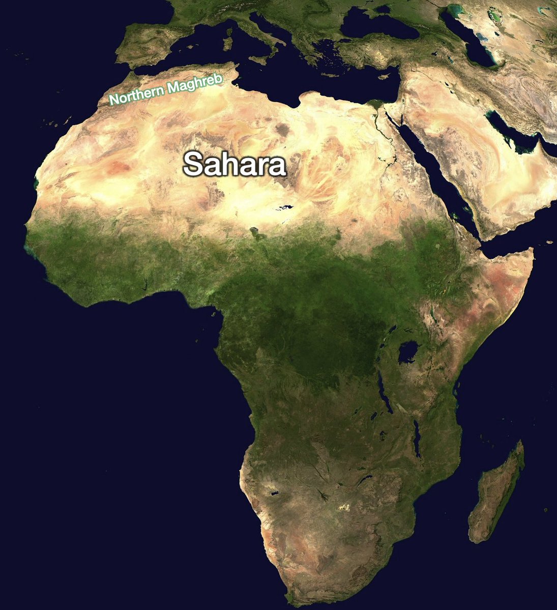
Let's zoom first into Africa's north. The northwest is a green stripe, but the rest is nearly all a complete desert. Why? https://t.co/Uy6mHn7gJK
You can't answer that question before wondering: Why is that massive Sahara desert there? Was it man-made? Has it always been there?
No https://t.co/POQRFfaXi2
It's in the Horse Latitudes, the part of the Earth that gets the most deserts. Why? Because cool, dry air falls from the atmosphere here, preventing other winds from unloading their moisture. Why? https://t.co/sWxhOeVoFw

The equator is the warmest region. There, water evaporates, and the hot air that carries goes up because hot air is less dense
As it rises, the air cools, and the moisture drops as rain
The air keeps rising, and with the Earth's rotation it falls... in the Horse Latitudes https://t.co/HZThW9Nmxs
So that's why the Sahara is there: Africa is the unlucky continent that has the biggest continuous landmass in the Horse Latitudes
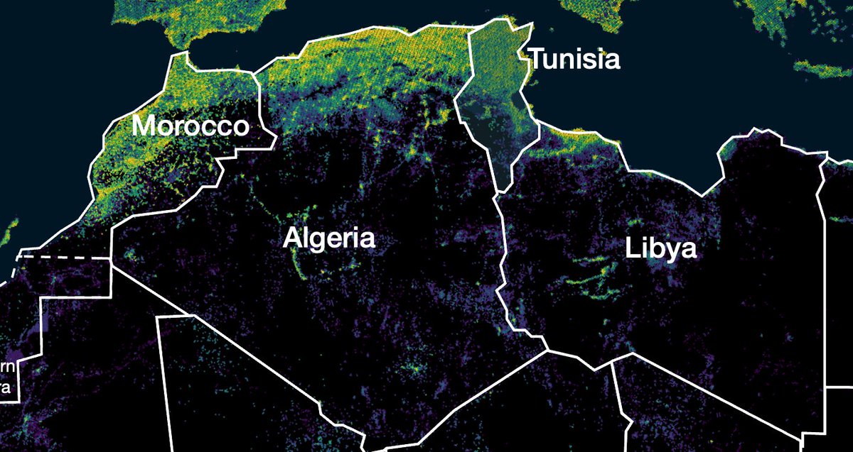
The north of Morocco, Algeria, and Tunisia avoid that drought: they're just above these latitudes, surrounded by water https://t.co/RV8nlfc6lX

Critically, wind blows from the Atlantic here, and pushes the humid air into the Atlas Mountains that cross these countries—one of the tallest ranges in Africa.
Altitude map: https://t.co/gTtPmodJ0K

And as we know, mountains catch humidity: as air climbs up, it cools down and condenses water, which rains down.
Without the Atlas Mountains, this moisture would move into the Sahara, which would make it wetter and these regions drier. https://t.co/DF91YCu0eO
Unsurprisingly, most of these countries' ppl live in the northern stripe. Eg, Algeria is the continent's biggest country, but 91% of its ppl live on the coast.
It's also why Tunisia is 10x smaller than neighboring Libya, but has 2x the population
Pop density map: https://t.co/Kyblxb9FmK
Libya is unlucky: it's also on Africa's Mediterranean coast, but a little too much south, so it remains entirely in the Horse Latitudes. The Atlantic winds drop their water in the Atlas before reaching it
Except for these small tips
Altitude map: https://t.co/zRK179Kq4V

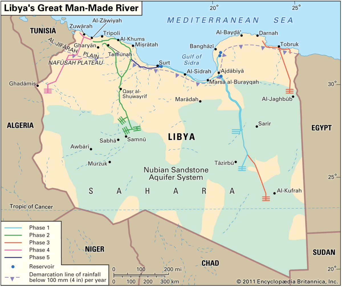
That's not enough water, so Libya chased it where it could—underground
Can you see the big mountain range in the previous map? It catches moisture, which flows underground to the northern valley. There, pipelines catch it & transport it to the coast https://t.co/OqCIu7mOSo
Moving further east, we find Egypt, which would be exactly like Libya if it weren't for the Nile
99% of Egyptians live on its shore which is just 3% of its territory! The video below illustrates this strikingly, both at night and during the day https://t.co/iBTPbWPHEC
More details on Egypt in the thread about the country.
https://twitter.com/tomaspueyo/status/1441223770706898944
One thing that is striking is that all these North African countries have a green band with all the ppl, but then they own a huge part of the Sahara. Why?
The Sahara has nearly nothing: few people, little water, little money
So it was always controlled by its neighbors, whether they came from the north or the south.
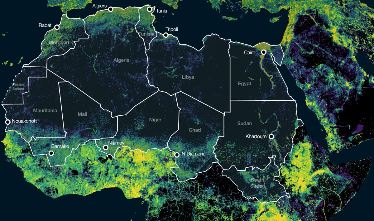
You can see it in a population map from today: https://t.co/WmpmyKdz7f

Morocco, Algeria, Libya and Egypt have a populated northern coast (+Nile) and desert to their south
Their southern neighbors are the opposite: in Mauritania, Mali, Niger, Chad, and Sudan, most ppl are in the south
The Sahara was basically split in half and shared between them
Look at the capitals: every single one of them is close to their countries' borders (or on the Nile)
This is one of the reasons why the Sahara has so many straight lines for borders: European colonizers had few mountain ranges, rivers, people, or wealth to delineate https://t.co/1HhQ28slxK
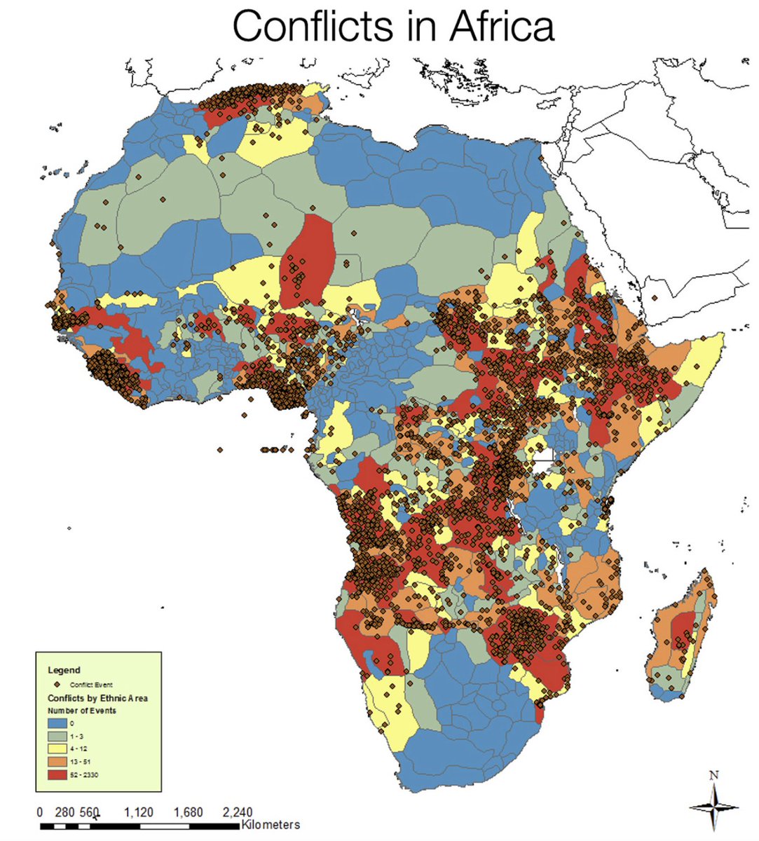
But that was stupid. Packing in one country border ppl, mountain ppl, and desert ppl, then giving the power to the borders away from the center, is a recipe for conflict https://t.co/aLoeisD7Y4
It's also why the latest new country in the world is South Sudan: Sudan used to reach farther south than any other Sahara neighbor, chasing the source of the Nile
But ppl inhabiting the Nile in the Sahara are different than those in the sahel, savanna, swamps, jungle... https://t.co/jcMMqQxh9a


What about neighboring Chad? Its most fertile region is Lake Chad, which reaches the sahel and the southern Sahara
Unsurprisingly, it's in high demand, so it ended up straddling 4 countries: Chad, Niger, Nigeria, and Cameroon https://t.co/mrthhyfQFR

How do you end up with a lake in the middle of the continent?
Africa is so big, hot, and mountainous that some of its rivers never reach the ocean.
Lake Chad is surrounded by mountains that push river waters towards their center, and form this salty lake https://t.co/MejpolRhZr

But why does water reach the southern end of Mauritania, Mali, Niger, Chad, and Sudan? Because of the monsoon
This shows rain in Africa throughout the year.
Note the blue band going up and down
It's the monsoon, which reaches the southern tip of these countries https://t.co/ZFwjngmPFp
In the case of Mali and Niger, they have something else: the Niger River
It's born near the coast, but Africa is so mountainous that it goes all the way to the Sahara before turning back and ending in the Gulf of Guinea
Mali and Niger's capitals are on the river https://t.co/rQBJohpgnB

The Niger River is so huge and important that 2 countries are named after it, Niger and Nigeria
Unfortunately, it's not navigable by big ships. Even smaller ones can only navigate it some times: it has sandbanks, rapids, waterfalls, and floods https://t.co/cHyLaUlZGU

This means much less trade than in navigable rivers like in Europe or the US, which means more poverty.
This is due to the region's:
• Mountains: rapids & waterfalls
• Latitude: it's so hot that no snowpack forms to delay the floods. Monsoon waters rush down https://t.co/Gt4p4So904

I ran out of tweets.
If you liked this, I'll continue & write more threads distilling the rest of Africa's main features.
Let me know by retweeting the 1st tweet
And follow me and subscribe to my free newsletter to not miss anything
https://unchartedterritories.tomaspueyo.com/subscribe